The storage capacity of the Great Lakes is 22,950 billion cubic metres of water, or the equivalent of over six million Olympic pools.
Modernization of the Beauharnois–Les Cèdres hydropower complex
Discover the facilities
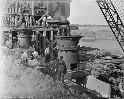
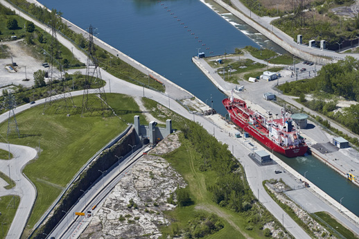
Built in 1911, the Beauharnois–Les Cèdres hydropower complex has played a very important role in the development of hydroelectricity in Québec. Today, it continues to play a major part in Hydro-Québec's generating fleet.
The structures that make up the complex are between 50 and 107 years old. That’s why Hydro-Québec is currently carrying out studies and investigations on all of these structures to determine what work will be required to ensure their long-term operability and extend their lifespan by several decades.
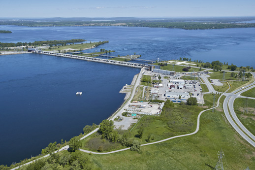
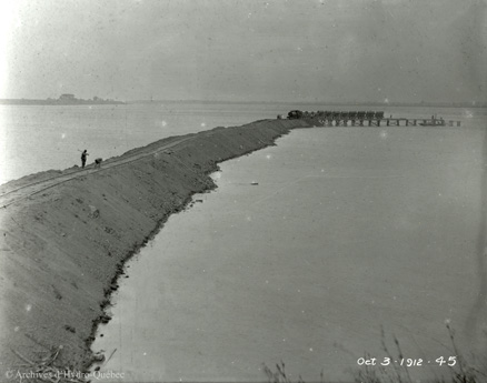
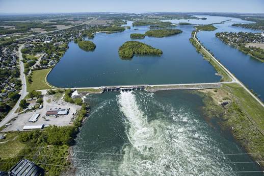
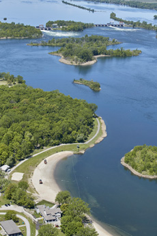
In addition to two generating stations, Beauharnois and Les Cèdres, the complex includes nine dams: Coteau-1, Coteau-2, Coteau-3 and Coteau-4, Île-Juillet-1 and Île-Juillet-2, Saint-Timothée, Pointe-du-Buisson and Pointe-des-Cascades. It also has retaining structures, including the 50-km-long Beauharnois canal dikes.
9 control structures
Over 50 kilometres of dikes
Age of structures: between 50 and 107 years
Click on the different elements shown on the map below
to find out more.


Infrastructure
-
Dike
-
Generating station
-
Dam
-
Canal
-
Dike
-
Locks
Limits
-
Municipality
-
Regional county municipality
Legend
Infrastructure
-
Dike
-
Generating station
-
Dam
-
Canal
-
Dike
-
Locks
Limits
-
Municipality
-
Regional county municipality
Beauharnois Generating Station
Beauharnois generating station is a run-of-river hydroelectric generating station built in three phases between 1929 and 1961. During this period, with its installed capacity of 1,643 MW, it became the largest generating station in Canada! Today, its 36 generating units with an installed capacity of 1,912 MW make it the fifth largest generating station in Québec and the largest run-of-river facility. Hydro-Québec became the owner of Beauharnois generating station in 1944, during the first phase of the nationalization of electricity in Québec.
Diaporama
Le contenu qui suit est un diaporama d’images sur : Beauharnois Generating Station
-
Aerial view during the construction of Phase 1 of Beauharnois generating station, which ran from 1929 to 1932 -
Phases 1 and 2 of Beauharnois generating station. Phase 2 was built between 1948 and 1951 -
Phases 1, 2 and 3 of Beauharnois generating station, as we know it today. The third phase was built between 1956 and 1961
Les Cèdres generating station
It is the second oldest (after Shawinigan-2, built in 1911) of the hydropower generating stations operated by Hydro-Québec and the first to result from the alliance between Shawinigan Water & Power and Montreal Light, Heat & Power. At the time of its commissioning, it was the most powerful facility in Québec with 74.8 MW. Today, its installed capacity is of 113 MW.
Diaporama
Le contenu qui suit est un diaporama d’images sur : Les Cèdres generating station
-
Workers in 1913 -
Construction work on Les Cèdres generating station in 1913 -
Les Cèdres generating station, built in 1914 -
Arial view of Les Cèdres generating station, as we know it today
Coteau-1 dam
This dam, built in 1933 by the Beauharnois Light, Heat and Power Company, is one of four dams on the Coteau whose main functions are to maintain the level of Lac Saint-François and to facilitate the flow of water to the Beauharnois canal and Les Cèdres generating station headrace canal.
- Length: 320 m
- Number of gates: There are 20 openings in which 18 gates are located. Two openings have been sealed with concrete beams
Diaporama
Le contenu qui suit est un diaporama d’images sur : Coteau-1 dam
-
View from upstream to downstream of the Coteau-1 dam, with the Monseigneur-Langlois bridge
Coteau-2 dam
This dam, built in 1934 by the Beauharnois Light, Heat and Power Company, is one of four dams on the Coteau whose main functions are to maintain the level of Lac Saint-François and to facilitate the flow of water to the Beauharnois canal and Les Cèdres generating station headrace canal.
- Length: 130 m
- Number of gates: The dams’s eight gates were concreted over in the 1990s
Diaporama
Le contenu qui suit est un diaporama d’images sur : Coteau-2 dam
-
Coteau-2 dam
Coteau-3 dam
This dam, built in 1940 by the Beauharnois Light, Heat and Power Company, is one of four dams on the Coteau whose main functions are to maintain the level of Lac Saint-François and to facilitate the flow of water to the Beauharnois canal and Les Cèdres generating station intake canal.
- Length: 270 m
- Number of gates: 16
Diaporama
Le contenu qui suit est un diaporama d’images sur : Coteau-3 dam
-
View from downstream of the Coteau-3 dam. The Coteau-4 dam can be seen on the right
Coteau-4 dam
This dam, built in 1943 by the Beauharnois Light, Heat and Power Company, is one of four dams on the Coteau whose main functions are to maintain the level of Lac Saint-François and to facilitate the flow of water to the Beauharnois canal and Les Cèdres generating station intake canal. This is a retaining structure that complements the other three.
Length: 900 m
Diaporama
Le contenu qui suit est un diaporama d’images sur : Coteau-4 dam
-
Coteau-4 dam. On the left, the Coteau-3 dam can be seen from downstream
Île Juillet-1 dam
This dam was built in 1940 by the Beauharnois Light, Heat and Power Company to increase the flow through Les Cèdres generating station headrace canal and to restore water levels between the Coteau rapids and the generating station.
- Length: 91 m
- Number of gates: 5
Diaporama
Le contenu qui suit est un diaporama d’images sur : Île Juillet-1 dam
-
The Île Juillet-1 dam is on the right bank. The Île Juillet-2 dam can be seen on the left bank
Île Juillet-2 dam
This dam was built in 1941 by the Beauharnois Light, Heat and Power Company to increase the flow through Les Cèdres generating station headrace canal and to restore water levels between the Coteau rapids and the generating station.
- Length: 150 m
- Number of gates: 9
Diaporama
Le contenu qui suit est un diaporama d’images sur : Île Juillet-2 dam
-
The Île Juillet-2 dam seen from upstream to downstream. The Île Juillet-1 dam can be seen on the right bank
Pointe-des-Cascades dam
Like the Saint-Timothée and Pointe-du-Buisson dams, this dam was built in 1964 by Hydro-Québec to create water bodies to meet the concerns of property owners near the dam and restore the river to its original appearance.
The dam is 1,721 m long and includes a spillway with 14 gates, a weir with two sections on either side of the Île des Cascades (518 m and 210 m) and a skimmer near the right bank, which maintains an ecological flow downstream from the structure.
Diaporama
Le contenu qui suit est un diaporama d’images sur : Pointe-des-Cascades dam
-
Pointe-des-Cascades dam seen from upstream
Pointe-du-Buisson dam
The construction of the Pointe-du-Buisson (1960-1962), Pointe-des-Cascades (1964) and Saint-Timothée (1971) dams reflects the desire to create bodies of water for recreational and tourist uses between Saint-Timothée and Pointe-des-Cascades, and more specifically between the Île-Juillet and Lac Saint-Louis dams.
The dam is 1,588 m long and has three sections: a spillway, a weir and a skimmer. The spillway is 215 m long and has 14 gates. The weir, on the left bank, measures 457 m. The skimmer has two gates and ensures that an ecological flow is maintained downstream of the structure.
Diaporama
Le contenu qui suit est un diaporama d’images sur : Pointe-du-Buisson dam
-
Pointe-du-Buisson dam seen from downstream
Saint-Timothée dam
The construction of the Pointe-du-Buisson (1960-1962), Pointe-des-Cascades (1964) and Saint-Timothée (1971) dams reflects the desire to create bodies of water for recreational and tourist uses between Saint-Timothée and Pointe-des-Cascades, and more specifically between the Île-Juillet and Lac Saint-Louis dams.
- Length of spillway: 144 m
- Number of gates: 10
- Embankment with skimmer: 272 m
- Rockfill dike: 345 m
Diaporama
Le contenu qui suit est un diaporama d’images sur : Saint-Timothée dam
-
Saint-Timothée dam
Structure-1
This dike holding back water between the Rivière Saint-Charles and the Saint-Timothée basin underwent maintenance work in spring 2020.
Beauharnois canal dikes
Diaporama
Le contenu qui suit est un diaporama d’images sur : Les digues du canal de Beauharnois
-
The Beauharnois canal dikes were built during the construction of the canal. They are made off clay on the banks and off dredged materials
Les Cèdres generating station dike (les Cèdres right bank embankment)
The dam of Les Cèdres generating station was built in 1913 and 1914 at the same time as the generating station of the same name, in order to direct the water to the headrace canal to turn the turbines. The dam is currently undergoing a rehabilitation project.
Diaporama
Le contenu qui suit est un diaporama d’images sur : Les Cèdres generating station dike
-
Start of construction of Les Cèdres generating station in 1912
Lac Saint-Louis
The second widening of the Saint-Laurent east of Lake Ontario, this 148-km2 lake is located upstream from the island of Montréal. Water from the Saint-Laurent exiting the Beauharnois generating station turbines and the spillway of the Pointe-des-Cascades dam flows into this lake, as do two of the four outlets of the rivière des Outaouais (Ottawa River).
Diaporama
Le contenu qui suit est un diaporama d’images sur : Lac Saint-Louis
-
View of Lac Saint-Louis at the outlet of the generating units of the first two phases of the Beauharnois generating station
Lac Saint-François
At the outlet of this first widening of the Saint-Laurent east of Lake Ontario, with a surface area of 233 km2, the water follows the natural course of the river or passes through the Beauharnois canal.
Diaporama
Le contenu qui suit est un diaporama d’images sur : Le lac Saint-François
-
Aerial view of Lac Saint-François towards the entrance to the natural bed of the Saint-Laurent
Beauharnois canal and St. Lawrence Seaway
Between Lac Saint-François and Lac Saint-Louis, the Saint-Laurent has a difference in elevation of 25 m and an average flow of 7,400 m3/s. To take advantage of this hydroelectric potential, the Beauharnois Light, Heat and Power Company (BLHPC) asked the federal government to obtain the right to divert the Saint-Laurent and develop Beauharnois generating station. In 1929, the company was granted permission to build this canal, which is 25 km long and 1 km wide, on the condition that its primary purpose be the navigation of the St. Lawrence Seaway. Two locks were built on the left bank of Beauharnois generating station to allow ships to travel the difference in elevation.
Diaporama
Le contenu qui suit est un diaporama d’images sur : Beauharnois canal and St. Lawrence Seaway
-
Map of the original plan for the construction of the Beauharnois canal
Pointe-du-Buisson basin
This basin is located between the Saint-Timothée and Pointe-du-Buisson dams. Following the reduction in flow that occurred in the natural riverbed of the Saint-Laurent from 1930 to 1960, structures were built to maintain water levels that met the community’s needs, including vacationing needs. In addition, because managing the ice on the Saint-Laurent is a challenge every winter, some structures have been designed to stay open during the winter to reduce ice-related issues. Due to their design, these structures cannot be operated in the winter. Water levels are therefore always low during this season.
Diaporama
Le contenu qui suit est un diaporama d’images sur : Pointe-du-Buisson basin
-
The Pointe-du-Buisson basin is located upstream from the dam of the same name
Pointe-des-Cascades basin
This basin is located between the Pointe-du-Buisson and Pointe-des-Cascades dams. Following the reduction in flow that occurred in the natural riverbed of the Saint-Laurent from 1930 to 1960, structures were built to maintain water levels that met the community’s needs, including vacationing needs. In addition, because managing the ice on the Saint-Laurent is a challenge every winter, some structures have been designed to stay open during the winter to reduce ice-related issues. Due to their design, these structures cannot be operated in the winter. Water levels are therefore always low during this season.
Diaporama
Le contenu qui suit est un diaporama d’images sur : Pointe-des-Cascades basin
-
The Pointe-des-Cascades basin is located upstream from the dam of the same name
Saint-Timothée basin
This basin is located between the Île-Juillet and Saint-Timothée dams. Following the reduction in flow that occurred in the natural riverbed of the Saint-Laurent from 1930 to 1960, structures were built to maintain water levels that met the community’s needs, including vacationing needs. In addition, because managing the ice on the Saint-Laurent is a challenge every winter, some structures have been designed to stay open during the winter to reduce ice-related issues. Due to their design, these structures cannot be operated in the winter. Water levels are therefore always low during this season.
Diaporama
Le contenu qui suit est un diaporama d’images sur : Saint-Timothée basin
-
The Saint-Timothée basin is located upstream of the dam of the same name -
View of the Saint-Timothée basin, downstream from the Île-Juillet dams
Beauharnois locks
Diaporama
Le contenu qui suit est un diaporama d’images sur : Les écluses de Beauharnois
-
Two locks were commissioned in 1959. The primary purpose of the Beauharnois canal is the navigation of the St. Lawrence Seaway
Saint-Louis (Hungry Bay) canal intake
This water intake was built in 1929 to regulate the flow of water through the Saint-Louis canal.
Diaporama
Le contenu qui suit est un diaporama d’images sur : La prise d’eau du canal Saint-Louis
-
Saint-Louis canal today. The water intake is located under the Chemin du Canal
Learn more
Until the end of 2021, Hydro-Québec will be conducting technical and environmental studies and investigations on all the structures in the Beauharnois–Les Cèdres complex.